
GIS का क्या मतलब होता है भू-स्थल सूचना प्रणाली, जो कि भूमि और उस पर स्थित object के डेटा को finding करने के लिए उपयोग की जाती है। इसके माध्यम से लोग idea लगा पाते ओर आने वाले समय में किसान अपने खेत में आनाज उगाने के लिये सह्यता ले सकता हैं, जैसे कि ज़मीन का उपयोग को मापने के उदेश्ये , बांधकाम , सडक निर्माण , नदी का उगम ओर तो खनिज और पर्यावरण संरक्षण। इससे सामान्य व्यक्ति को भूमि के संबंध में अधिक जानकारी प्राप्त होती है, जिससे उन्हें अपने निर्णयों को सुनिश्चित और सही बनाने में मदद मिलेगा ।
बिना साइंस भाषा का उपयोग किये, जैसे कि Gis विषय में विशेषज्ञ होता है, मैं इसे सरल शब्दों में समझाने की कोशिश करते हे
ज़मीन का उपयोग: GIS जमीन के उपयोग को अधिक सरळ और सहज बनाता है। यह लोगों को उनकी जमीन की जानकारी प्राप्त करने में मदद करता है, जैसे कि किसानों को खेतों का बेहतर प्रबंधन करने में उपयोग हो रहा है।
निर्माण: यह बांधकाम ओर बने वाले क्षेत्र में महत्वपूर्ण भूमिका निभाता है। इसके माध्यम से भू-स्थल के विवेकपूर्ण चयन, नक्शा बनाने, और निर्माण प्रक्रिया के साथ संबंधित डेटा का प्रबंधन किया जा रहा है।
बांधकाम: संगठनों और सरकारों में, यह उपयोग किया जाता है जिससे समयानुसार सही निर्णय लिए जा सकें। उदाहरण के रूप में, एक शहरी निगम GIS का उपयोग करके अपने इन्फ्रास्ट्रक्चर की निगरानी कर सकता है और शहर के विकास को प्राथमिकता दे रहे हे।
पर्यावरण संरक्षण : GIS पर्यावरण संरक्षण में भी महत्वपूर्ण भूमिका निभाता है। यह जलवायु परिवर्तन, वनस्पति और जैव विविधता के अध्ययन के लिए उपयोग किया जा रहा है, जो जलवायु परिवर्तन के प्रभावों का मूल्यांकन करने और जलवायु बदलाव को प्रबंधित करने में मदद कर रहा है।
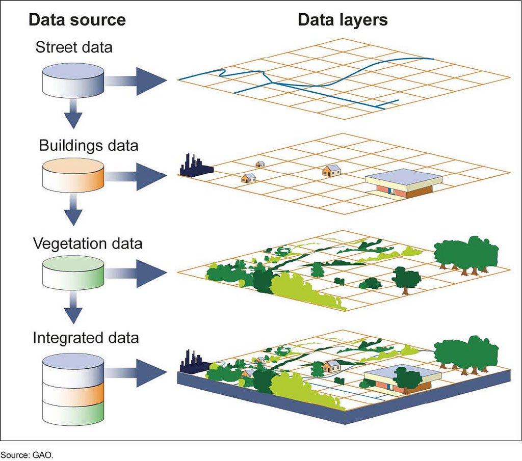
GIS Structure
Content in English
What does GIS mean? Geospatial Information System, which is used to find data about land and objects located on it. Through this, people are able to generate ideas and in the future, farmers can take permission for growing grains in their fields, for the purposes of measuring land use, construction, road construction, river origin, minerals and environmental protection. With this, the common man gets more information regarding land, which will help him in making sure and correct decisions.
Without using science language, as Gis is an expert in the subject, I try to explain it in simple words.
Land Use: GIS makes land use more straightforward and intuitive. It helps people get information about their land, such that farmers are using it to better manage their farms. Construction: It plays an important role in construction and built sector. Through this, data related to judicious selection of land, mapping, and construction process is being managed.
Construction: It plays an important role in construction and built sector. Through this, data related to judicious selection of land, mapping, and construction process is being managed. Construction: In organizations and governments, it is used so that right decisions can be taken in time. As an example, an urban corporation can use GIS to monitor its infrastructure and prioritize the development of the city.
Environmental Protection: GIS also plays an important role in environmental protection. It is being used to study climate change, vegetation and biodiversity, helping to evaluate the impacts of climate change and manage climate change.